NAIP: The Loss of a Public Good
By Jon Engelsman
January 11, 2018
An analysis of how the Department of Agriculture might be thinking about the future of the National Aerial Imagery Program.
Losing NAIP
A recent blog post by the location data platform Mapbox voiced concern for the future of a free, publicly-available data set of high-resolution aerial imagery of the United States.
Mapbox’s Charlie Lloyd, a satellite and aerial imaging processing specialist, raised concern over a “leaked” slide deck from the US Department of Agriculture (USDA) which suggests that the imagery data provided by the National Agriculture Imagery Program (NAIP) could “move from open data to a licensed system”.
Evidence from government agency documentation reveals that a bigger concern might not be just losing open access to such a valuable data source, but actually losing any access.
A History of NAIP Funding
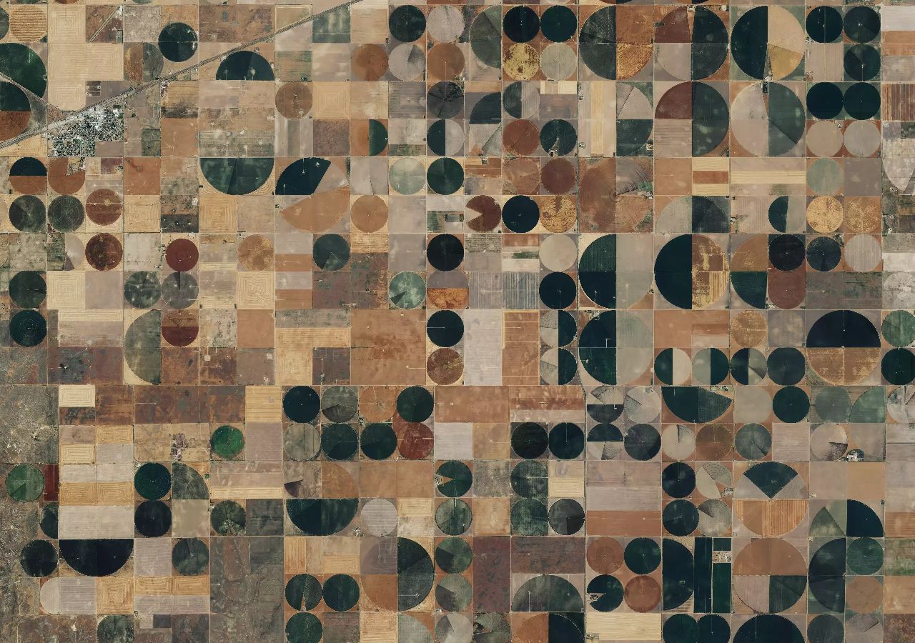
Since 2003, the NAIP has been administered by the USDA’s Farm Service Agency (FSA) through the Aerial Photography Field Office (APFO) based out of Salt Lake City, Utah. Its mission is to provide high-resolution aerial imagery of US farmland during peak growing seasons to USDA County Service Centers in order to “maintain Common Land Unit (CLU) boundaries and assist with farm programs”.
By design, the NAIP is primarily funded by the FSA directly with additional cost-share partnerships between other federal and state entities. These funds are then used to pay for aerial imagery collection campaigns by private contractors, prioritizing the imaging of states which have paid in each year.
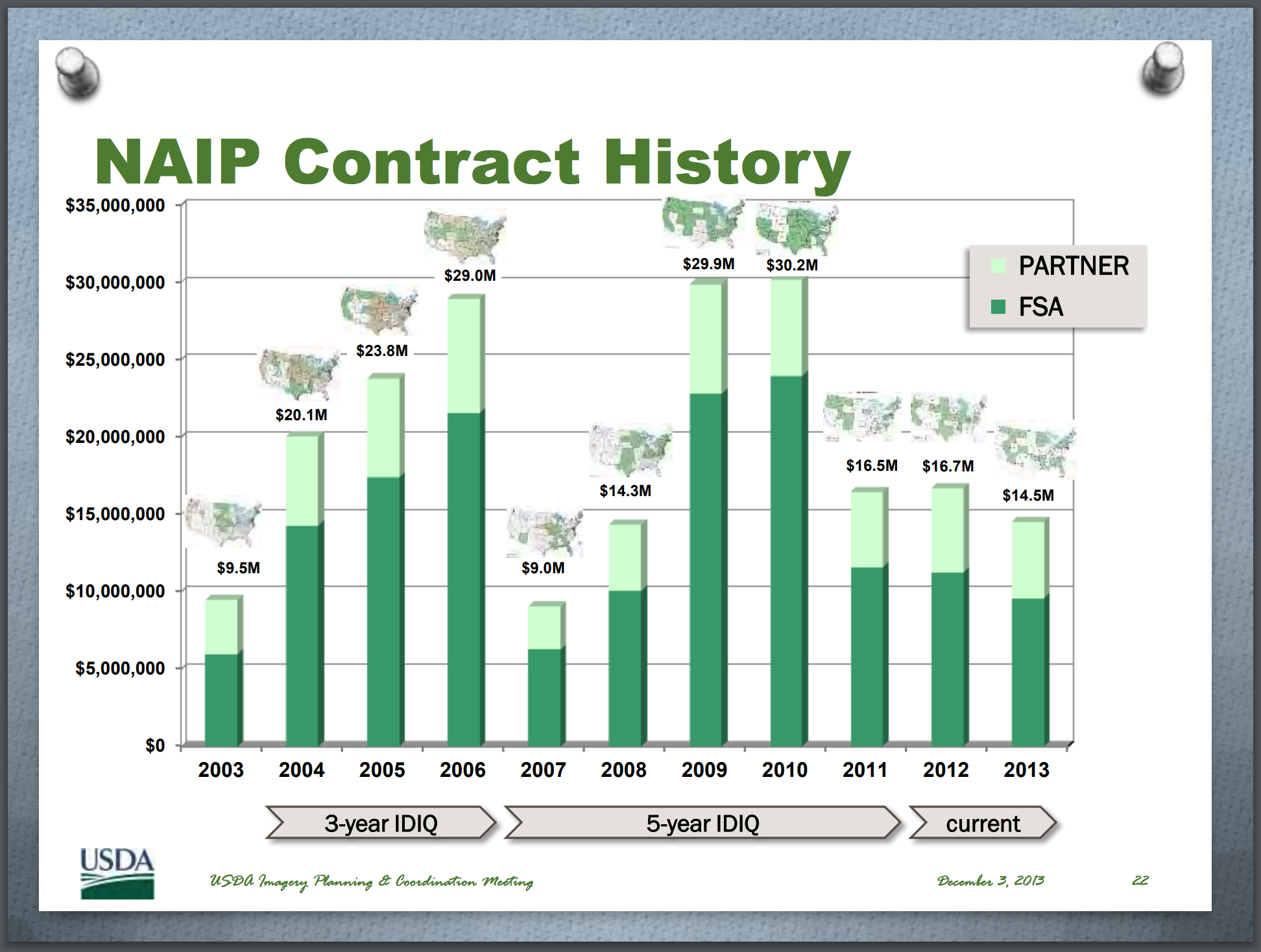
Throughout its history, the FSA has footed the majority of the bill for the NAIP contracts relative to its partners, as shown in this graphic from a 2014 presentation.
A New Acquisition Strategy
The FSA not only consistently carries the financial burden of funding the NAIP program but also has to deal with other “partner induced program risks”, such as cost-share partners either coming up short on funding commitments or delaying the release of funds which ends up pushing data collection campaigns past “peak-growth” season. As a result, it appears that the FSA is looking to make a budgetary-induced change to the NAIP program.
The slide deck referenced in the Mapbox blog post was presented by APFO officials at a coordination meeting with the Federal Geographic Data Committee (FGDC) on November 14th, 2017. In it, the APFO presents a case for using a Commercial-Off-the-Shelf (COTS) acquisition strategy for NAIP imagery, what they refer to as a “licensed model”.
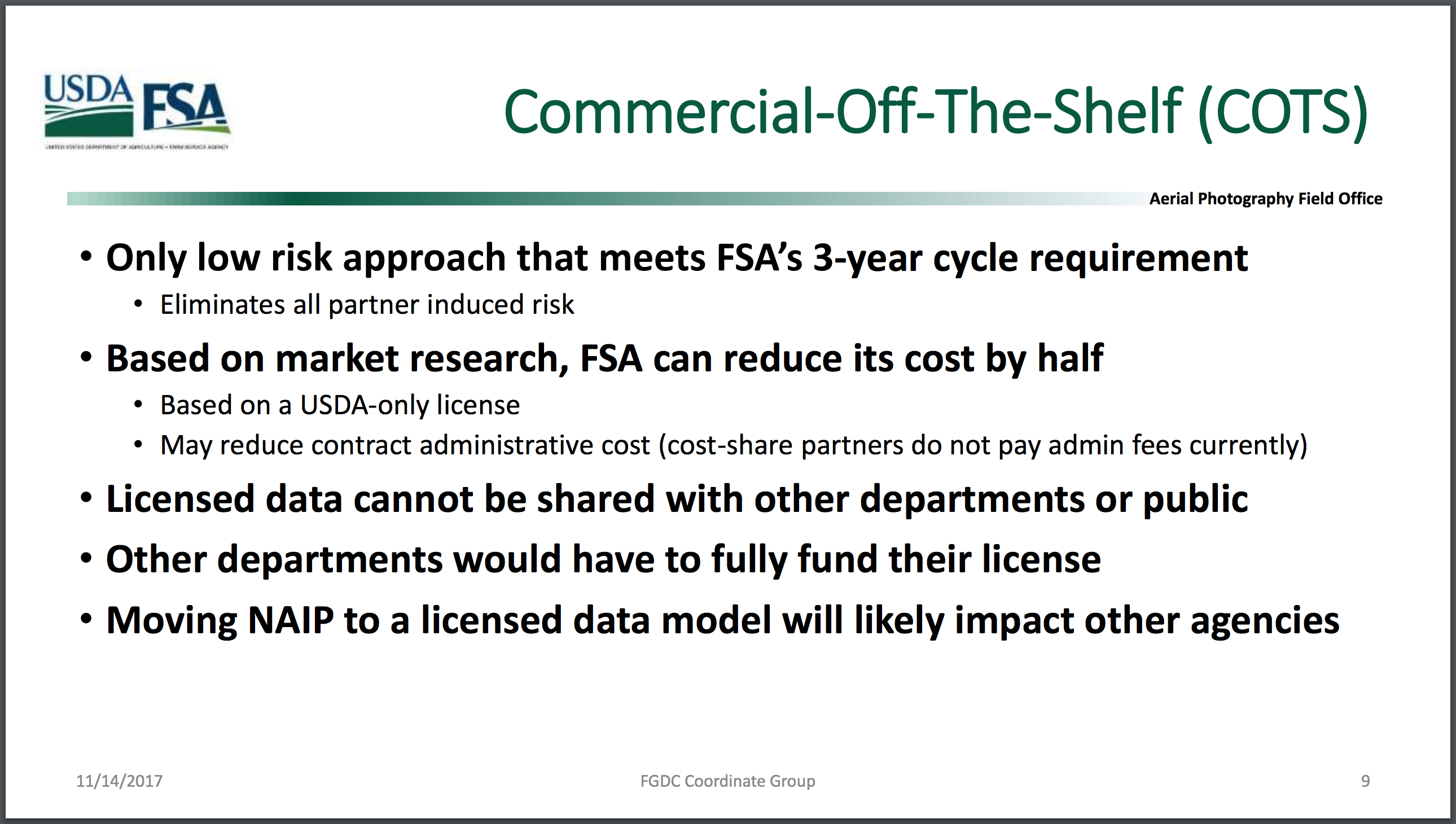
The “licensed model” being considered by the APFO represents a new cost-savings approach for the NAIP by leveraging commercially-available, high-resolution imagery at a fraction of the cost of contracting out aerial imagery collection campaigns. It’s not clear from the presentation what type of commercial imagery the APFO is considering for the NAIP, but some requirements listed in the presentation offer a possible clue.
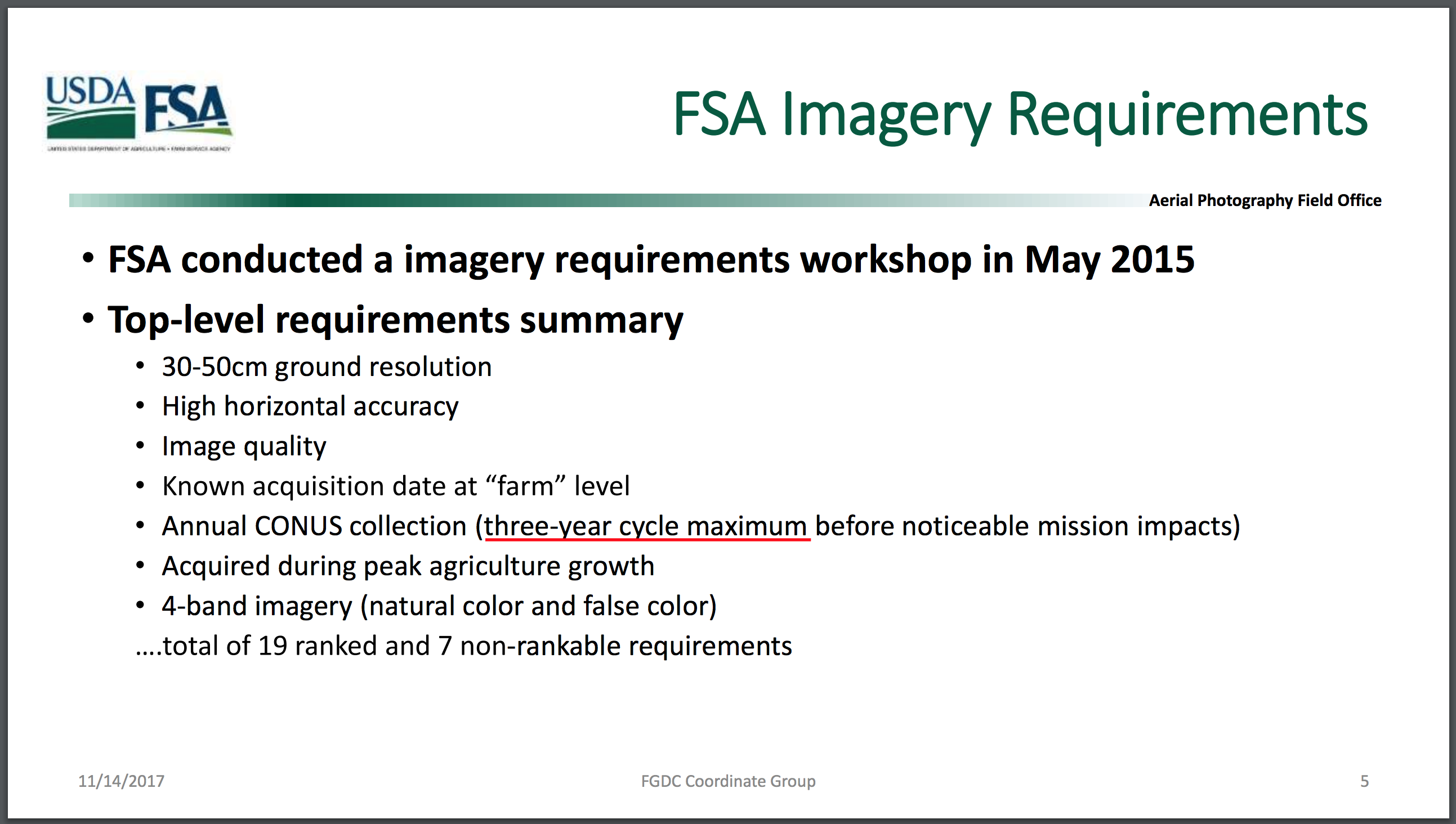
The proposed imagery requirement of “30-50 cm ground resolution” exceeds the 1-meter resolution currently provided by the NAIP data set via aerial imagery. But such high-resolution imagery is now available through commercial, satellite-based imagery vendors like DigitalGlobe, which started offering 30 cm resolution imagery in early 2015.
Additional detail of the proposed change is provided in a notice sent out by the FSA two weeks after the FCDG coordination meeting in November, asking all state offices for information on how they use and share NAIP imagery data. The notice included a background statement on a potential change to the NAIP acquisition strategy:
“Since the start of NAIP in 2003, all acquired imagery has been placed in public domain allowing unrestricted use and sharing of the data. However, the exponential growth of GIS and the demand for high resolution imagery in both public and private sectors have created new commercial imagery sources. Changing NAIP acquisition strategy to using commercial off-the-shelf (COTS) imagery could potentially save FSA funding and resources.”
Currently, the USDA’s FSA (through the APFO) contracts out aerial imagery data collection to three primary contractors: North West Geomatics, Surdex Corporation, and Quantum Spatial. A review of FSA contracts awarded to these three companies shows over $130 million for NAIP-related services since 2009.
Depending on how the USDA’s FSA defines the requirements of the NAIP going forward, it’s possible that they could save millions of dollars by transitioning away from aerial imagery contracts to commercially available imagery while still providing the data needed by federal, state and local agricultural agencies. As noted in the slide deck, they expect that “FSA can reduce its cost by half” for a “USDA-only license”.
Commercial Data and The Public Good
With the distribution restrictions that would come with purchasing licensed, commercial imagery data, the APFO readily admits that this could impact the wide-spread use of NAIP imagery by other government agencies and the public. Aware of the likelihood of political “blow-back”, they argue that “reducing FSA spending while meeting or maintain [sic] mission requirements is defendable”.
The USDA’s FSA has also conceded that they “have not identified any regulatory or statutory requirements that mandate the release of NAIP data set to the general public”. It’s clear from this language that the USDA’s FSA isn’t simply looking to restrict access to the NAIP under a new commercial acquisition strategy, but in fact are prepared to no longer provide it to the public at all.
However, there are some clear warnings against this type of mentality from within the government’s own earth observation community.
Tim Stryker, Former Director of the US Group on Earth Observations Program in the White House’s Office of Science and Technology Policy, was an author of the 2014 National Plan for Civil Earth Observations report, a report in which the NAIP was ranked #5 in high-impact earth observation systems. At a UNAVCO board meeting in early 2016, a question was posed about how commercial data licensed to one government agency might be used by others.
“I don’t think Federal agencies should allow for the ‘mercantilizing’ of a public good”, Stryker said. He then suggested that conversations with agency scientists and program managers should start with the question of “how data, whether it’s commercial or not commercial, can best feed a variety of public programs”. Additionally, Stryker’s response offers a clear warning to government agencies that “sometimes a commercial off the-shelf data product may not be the best fit for purpose.”
It’s unclear if the NAIP would maintain its high ranking in the comparison of civil earth observation systems after transitioning to commercially-acquired imagery and closing off a valuable resource to the public. But such comparisons can be important to the extent that they highlight the valuable, downstream contributions of taxpayer investments, as in the case of other well-recognized, high-impact earth observations systems like GPS, NEXRAD, Landsat and GOES (ranked #1-4, respectively).
Going Forward
The USDA’s FSA proposal for a new acquisition strategy of NAIP imagery seems best to be viewed as a cost-savings effort, a commendable and challenging act in most government budget offices. However, the proposal to use commercial imagery for the NAIP, and the associated licensing restrictions that might prevent broad distribution, would result in a significant loss to the public as well noted by Mapbox’s Lloyd. With a better understanding of the budgetary constraints of the current NAIP acquisition method, the imagery needs of the USDA and other government agencies and the impact to the public, it’s possible that a better path forward exists for the future of the NAIP.
Additional Reading
- Mapbox, “Keeping NAIP free & open” by Charlie Lloyd
- USDA’s FSA APFO Presentation, “NAIP 2019”
- National Agriculture Imagery Program (NAIP) Information Sheet
- 2014 National Plan for Civil Earth Observations