N515JA: A Most Unusual Gulfstream
By Jon Engelsman
December 6, 2020
On the mysterious flights of a modified Gulfstream aircraft and a plausible explanation regarding atmospheric measurements for hypersonic missile testing.
On December 1st 2020, the Twitter account Advisory Circular Minneapolis-St. Paul posted a recent flight of N515JA, a Gulfstream IV aircraft flying circles at 42,500 ft above Minneapolis, Minnesota. Developed by John Wiseman ( @lemonodor), this Twitter account is part of the Advisory Circular network, a collection of automated bots that identify aircraft flying circular paths over various cities.

In response to this notification, Wiseman and @JetTipNet (a Minnesota-based flight alert service) both posted detailed threads highlighting the curious history of N515JA, a history which includes some eyebrow-raising flights over the state of Michigan in June 2020, some unusual modifications to the aircraft, and some press releases provided by the aircraft owners.
After seeing these threads, I sought out to better understand the nature of N515JA and its flights. Based on what I’ve been able to put together, I outlined my suspicions and their supporting clues in the Twitter thread below.
Similarly, the following post will outline in more detail my conclusion that N515JA is an airborne platform for the United States Air Force’s High-Altitude LIDAR Atmospheric Sensing (HALAS) system and is intended for use in hypersonic missile testing.
N515JA
N515JA is a 1988 Gulfstream IV twin-jet aircraft. Its history prior to 2015 is unclear. From 2015 to 2020, it appears to have been owned by MF Holdings Group LLC and operated as a 12-passenger charter jet by Journey Aviation.
Initial Observations
On June 19th 2020, aviation photographer and Michigan-based aircraft mechanic Mike Kelly posted a YouTube video highlighting a series of observations by the Michigan aviation community regarding the unusual nature of N515JA. This video appears to be one of the first recorded instances of these observations.
In summary, Kelly noted the following:
- On May 26th 2020, N515JA flew into Willow Run Airport (KYIP), Michigan in a standard configuration. It emerged 16 days later on June 11th with externally visible modifications, most notably with what appeared to be an optical glass window on the left side of the aircraft.
- Sources at Gulfstream were unfamiliar with the modifications as they did not install them.
- On June 6th, Traverse City 911 received numerous calls about a suspicious aircraft flying overhead.
- Since June 11th, N515JA began flying almost daily test flights of the following nature:
- Flight durations of 2-4 hours
- Continuous right turn circles at 43,000 ft altitude with speeds varying between 450-600 knots
- Flight paths circling over Flint and Traverse City airports in Michigan
- ATC-assigned squawk codes of 7441 during some flights (additionally noting that squawk codes in the 7400 range usually indicate uncrewed or autonomous flights)
The YouTube video also includes a photo of N515JA that shows the noted modifications to the aircraft. This photo was presumably taken on June 6th at KYIP, as indicated in a Facebook post by the account MT Aviation photo and film from June 11th.
 Image: MT Aviation Photo & Film -MTrain999, via YouTube
Another image from the same YouTube video provides a zoomed-in look at the left rear window modification, highlighting what appears to be a fiberglass cover over two of the aircrafts left rear windows, with one of the windows having what appears to be an optical glass window.
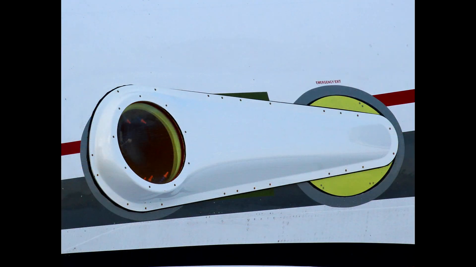 Image: MT Aviation Photo & Film -MTrain999, via YouTube
It should be noted that the optical glass window has a slight upward angle relative to the normal orientation of a Gulfstream IV window. This upward angle is more apparent in an October 27th photo of the aircraft.
 Image: © CanAmJetz
Additionally, Twitter user @jsrailton has noted that the orange objects inside of the window look to be Loc-Line nozzles, likely intended to “blow air on the (presumably optical) glass to keep it from frosting/fogging” and avoid “unwanted scattering in a laser application”.

Summer 2020 Flights
On June 28th 2020, the Traverse City Record-Eagle posted a story about the mysterious flights of N515JA which included the previously described observations of Mike Kelly and others. (Note, this story was also picked up the same day by the aviation publication AviationPros).
 Image: Record-Eagle/Jan-Michael Stump
A week earlier, in response to another story of sky circles over Traverse City, Twitter user @daBears5280 posted a photo showing similar sky circles over Fife Lake, Michigan, just southeast of Traverse City. It is presumed that these stories and photos were related N515JA flights during that time.

A follow-up story posted a week later by the Record-Eagle (paywall), and again picked up by AviationPros, provided additional detail on the recent flights of N515JA based on a statement released by Journey Aviation, the owners of N515JA at that time.
“N515JA is a modified Gulfstream to conduct atmospheric research and currently in developmental and testing phases,” said Fabian Bello, chief executive officer of Journey Aviation in Boca Raton, Florida. “For this reason we fly in the same areas and patterns to receive consistent results. Our atmospheric testing is with a commercially developed sensor on board that is of proprietary but not classified nature,” Bello added. “While we cannot provide specific details of the sensing unit onboard, rest assured this is no clandestine or secret project of any sorts.”
AviationPros.com, July 6th 2020
These comments appear to be the first to indicate that the modifications to N515JA are intended for atmospheric research purposes, although a similar comment was posted by Thomas Fruendl on June 30th to the Michigan Planespotting Facebook group, based on an anecdotal source at an FAA Flight Standards District Office.
Ownership
On September 14th 2020, N515JA appears to have been officially acquired from MF Holding Group by its current owners, Aery Aviation LLC. The initial aircraft registration location appears to have been at Aery Aviation’s corporate headquarters in Newport News, Virginia, but its registration location has since changed to Wilmington, Delaware.
Aery Aviation
Aery Aviation LLC is an aviation design, engineering and systems integration company based out of a 17,000 sqft hangar located at the Newport News/Williamsburg International Airport (KPHF) in Newport News, Virginia. Aery appears to provide a wide range of aviation technical capabilities to both commercial and government customers, including the US Department of Homeland Security and the US Department of Defense.
It is unclear exactly how long Aery Aviation has been involved with N515JA prior to their obtaining ownership of the aircraft in late 2020. However, a company press release from August 21st 2020 noted that they had just completed a 12-month design and integration process of a Gulfstream IV “airborne research platform”.
Newport News, VA–Aery Aviation, LLC (“Aery”) has successfully completed the ground and flight tests of its latest airborne research aircraft allowing it to move onto the U.S. Air Force range operations. Over the last twelve months, Aery has designed, engineered, integrated specialized systems into our Gulfstream IV airborne research platform. This unique highly modified Gulfstream has capabilities not previously available on a commercial aircraft. As one part of this project, Aery provides the system integration, airframe modifications, flight operations and maintenance/logistics to keep the aircraft readily available for the end user. “This new development provides the end user government customer with a new airborne capability not previously available. This special mission upgrade includes onboard airborne technology not previously integrated into an aircraft and successfully operated before”, commented Scott Beale, Vice President of Aery Aviation.
Aery Aviation, August 21st 2020
Of interest is the comment that the system provides the government customer with “a new airborne capability…not previously integrated into an aircraft and successfully operated before.”
The press release goes on to describe an upcoming plan for the aircraft in the coming months.
Aery has completed the modification work form its Newport News, Virginia corporate headquarters and conducted flight operations at a variety of locations for the ground and test flight series. Aery is planning a series of secondary flights on a government range in the coming months to further prove its systems and capabilities. The ongoing expansion of operations will provide the government with a superb capability for years to come.
Aery Aviation, August 21st 2020
Additionally, in a page listing their previous projects and past performance, Aery lists a project that involved a “Gulfstream IV Zenith Port with Special Mission Laser Modification”. While the term “zenith” would otherwise typically imply something pointing directly above the aircraft, it may also refer to an upward pointing side window, similar to that of the observed N515JA modifications.
Furthermore, in a March 6th 2020 Facebook post, Aery provides another hint to the nature of modifications to what appears to be N515JA, highlighting the words “PROJECT LASER”.
 Image: Aery Aviation
Summary Part 1
In summary, the following items have now been established that might indicate the likely nature of N515JA’s modifications, namely:
- Externally visible aircraft modifications of an upward-facing optical glass side window with anti-fog air nozzles
- Pattern of flights that consist of high-altitude, long-duration circular right-hand turns
- Flights which have reportedly involved atmospheric research that is in the developmental and testing phases
- That the research is in support of a government customer
- This atmospheric research uses a commercially developed sensor of a proprietary but not classified nature
- The onboard airborne technology has not previously been both integrated into an aircraft and successfully operated before
- And that the technology involved is presumably laser-based
Based on this information, an online search for a military-backed, commercial technology that involves laser-based atmospheric research led to a technology called the High-Altitude LIDAR Atmospheric Sensing (HALAS) system.
The following information will attempt to link the HALAS technology to Aery Aviation and N515JA, specifically in establishing the premise that N515JA is an airborne testing platform for this technology.
HALAS
The High-Altitude LIDAR Atmospheric Sensing (HALAS) system was developed by the Michigan Research Corporation (MAC), “an advanced engineering and products company that provides innovative sensing, intelligent systems, and software solutions for space, air, and earth-bound applications.” Michigan Research Corp is headquartered in Ann Arbor, Michigan, roughly 10 miles west of KYIP airport where the modifications to N515JA have reportedly taken place.
The HALAS system appears to be a commercial product developed and sold by Michigan Research Corp, and is described as follows:
The High Altitude LIDAR Atmospheric Sensing (HALAS) System is a ground-based, UV LIDAR and Raman system for real-time, high-altitude measurement of wind velocity, direction, density, temperature, and composition – O2, N2, and H2O mass fractions. With an operating range of 0.6-50km+, HALAS is ideal for high-altitude vehicle testing, launch sites and test ranges. The directional pointing control and volumes of data produced are significantly beyond what is available with traditional balloon sondes. Part of our AeroForecast product line, HALAS provides the next generation of atmospheric intelligence and is available in a variety of portable and transportable solutions.
Michigan Aerospace Corp/HALAS
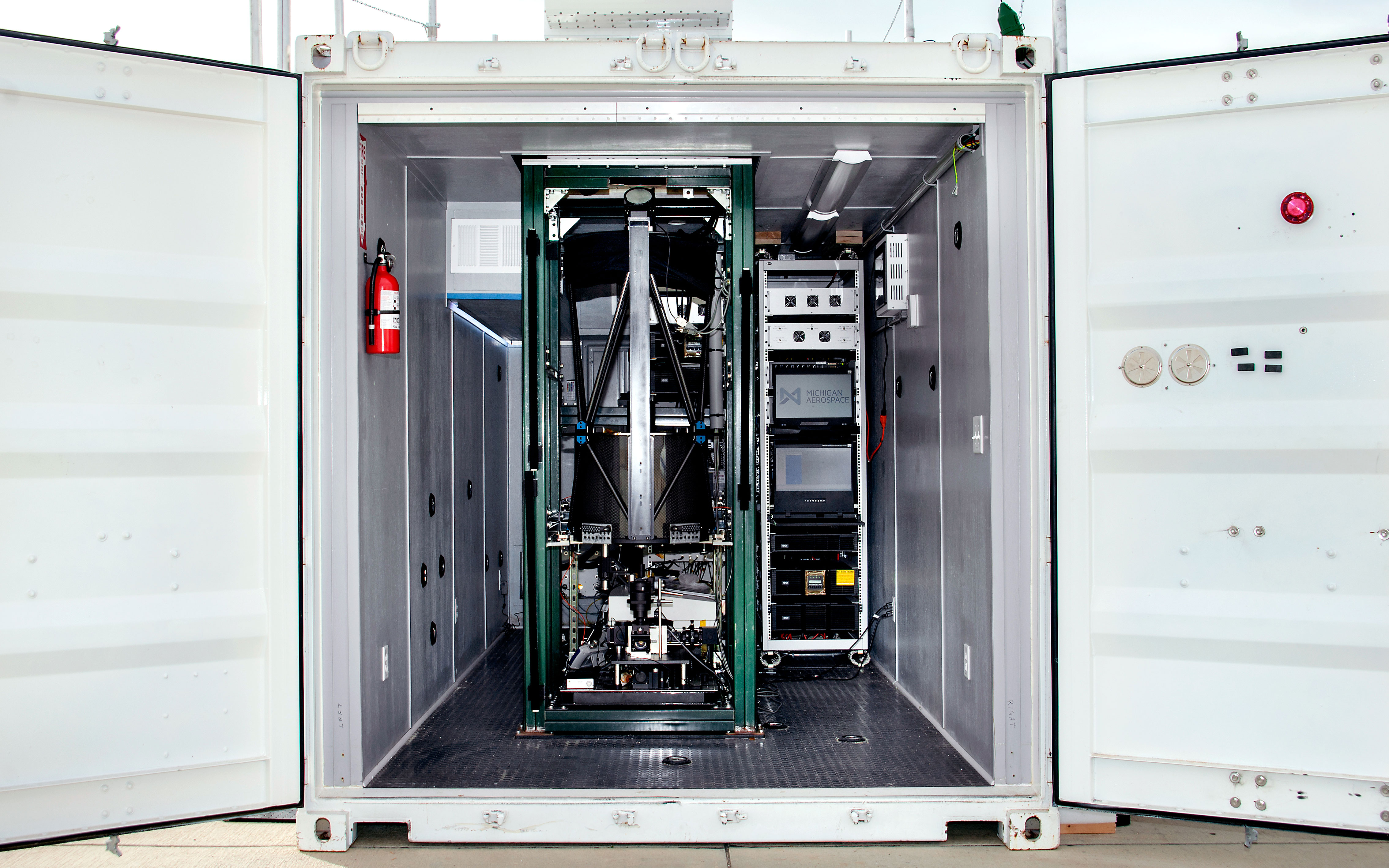 Image: Michigan Aerospace Corp
The HALAS technology appears to have been under development as early as 2006, when Michigan Aerospace Corp was awarded a $1 million contract as part of a larger grant from the National Oceanic and Atmospheric Administration (NOAA) to the University of New Hampshire. Although it’s unclear if this contract was specifically awarded for what is now the HALAS system, it does note that funds were provided for the launch of a “Light Detection and Ranging (LIDAR) atmospheric wind measurement instrument on a high-latitude Air Force ballon platform”.
Additionally, an October 2017 press release from Planewave Instruments (a telescope optical systems manufacturer based out of Adrian, Michigan), notes the following:
Michigan Aerospace was funded by NOAA to demonstrate long-range wind LIDAR technology for future satellite missions to measure global tropospheric winds. Built around a PlaneWave 20″ telescope, Michigan Aerospace developed the High Altitude LIDAR Atmospheric Sensing (HALAS) System as a ground-based, UV LIDAR and Raman system for real-time, high-altitude measurement of wind velocity, direction, density, temperature, and composition – O2, N2, and H2O mass fractions. With an operating range of 0.6-50km+, HALAS is ideal for high-altitude vehicle testing, launch sites and test ranges.
Planewave Instruments
It’s clear that Michigan Aerospace Corp developed the HALAS system with a wide-range of intended atmospheric research efforts, including both civilian and defense applications. And while the technology was originally developed as a ground-based system, it was also intended to be further developed into a portable system, to be deployed on satellite, airborne or additional ground-base platforms.
Tempus Applied Solutions
In October 2016, a company called Tempus Applied Solutions posted a blog entry announcing that they had received a $1.2 million contract to “provide technical services and flight operations to the US Air Force (USAF) Weapons Development and Integration Directorate”.
Tempus will integrate the USAF's High-Altitude LIDAR Atmospheric Sensing (HALAS) system into a modified Gulfstream IV aircraft owned by the Company. The laser-equipped sensor has the capability of measuring, with great precision, atmospheric conditions well into the stratosphere. Tempus will assist in the airborne testing of USAF's ground-proven HALAS system upon completion of the sensor integration and airframe modifications. If exercises are successful, atmospheric testing will be substantially improved, with a significant reduction in error factors from older sensing capabilities.
Tempus Applied Solutions, October 5th 2016
Modifications will take place at Tempus' Brunswick, Maine, modification center and will consist of significant engineering and electrical modifications, including the integration of an ultraviolet laser, telescope and advanced optical sensors. Under the contract, once the aircraft modifications have been completed, fifty hours of flight operations and testing are to be conducted by Tempus in the United States and selected oceanic areas.
Tempus Applied Solutions, October 5th 2016
It was also noted that the contract would be executed throughout 2017, with modifications occurring from June to September with flight operations slated to begin in October 2017. They also planned to begin offering the system both commercially and for the military starting in 2018, assuming successful testing of the system.
Similar to Aery Aviation, Tempus Applied Solutions provides “design, engineering, systems integration and flight operations solutions that support critical aviation mission requirements for a variety of customers”. Of particular interest is that the address for the Tempus Applied Solutions headquarters is located at the KPHF airport, in close proximity to Aery Aviation’s hangar.
However, the current business and financial status of Tempus Applied Solutions is unclear at this time, and although some curious records exist online, speculation on this matter will not be provided here. That being said, it is also notable that according to LinkedIn profile descriptions, some former employees of Tempus Applied Solutions are now employed at Aery Aviation, including a number of engineers and project managers.
Summary Part 2
In the Part 1 summary, we established that N515JA is a modified Gulfstream IV, currently owned and operated by Aery Aviation for a government customer with the purpose of providing atmospheric research sensing using a laser-based technology.
Now in Part 2, we’ve established these additional items:
- Michigan Aerospace Corp has invented a commercial, ground-based LIDAR atmospheric sensing platform called HALAS
- HALAS is a laser-based technology intended to provide atmospheric measurements for high-altitude vehicle testing, launch sites and test ranges
- Michigan Aerospace Corp is headquartered near KYIP airport, the same location where N515JA reportedly received its modifications and was reportedly based out of during flights in the summer of 2020
- Tempus Applied Solutions originally received a contract in 2016 to install a HALAS system in a Gulfstream IV aircraft
- Tempus Applied Solutions was previously headquartered at KPHF, the same airport where Aery Aviation is currently headquartered
- A number of former Tempus Applied Solutions employees now work at Aery Aviation
In taking the items from both of these summaries together, it could reasonably be assumed that Aery Aviation in some way took over the USAF/HALAS contract from Tempus Applied Solutions, and that Aery Aviation is now operating N515JA with an installed HALAS system for the US Air Force.
HALAS and the US Military
While Michigan Aerospace Corporation has established the HALAS technology as an atmospheric measuring system for the general use case of high-altitude vehicle testing, launch sites and test ranges, a specific use case for the HALAS system has apparently been established by the US military.
At the 33rd Annual National Test & Evaluation Conference hosted by the National Defense Industrial Association (NDIA), USAF Col Timothy D West provided a presentation titled “U.S. Air Force Investments in Hypersonic Test Technologies & Infrastructure”. In the presentation, the HALAS system is mentioned as being a current effort in the flight testing and evaluation of hypersonic missiles, providing “measurement of atmospheric flight conditions for flight tests” with “significantly more accurate test data and analysis and vehicle performance estimates”. One of the slides in this presentation specifically highlights the ground-based HALAS system, but also mentions proposed UAV and airborne versions as well.
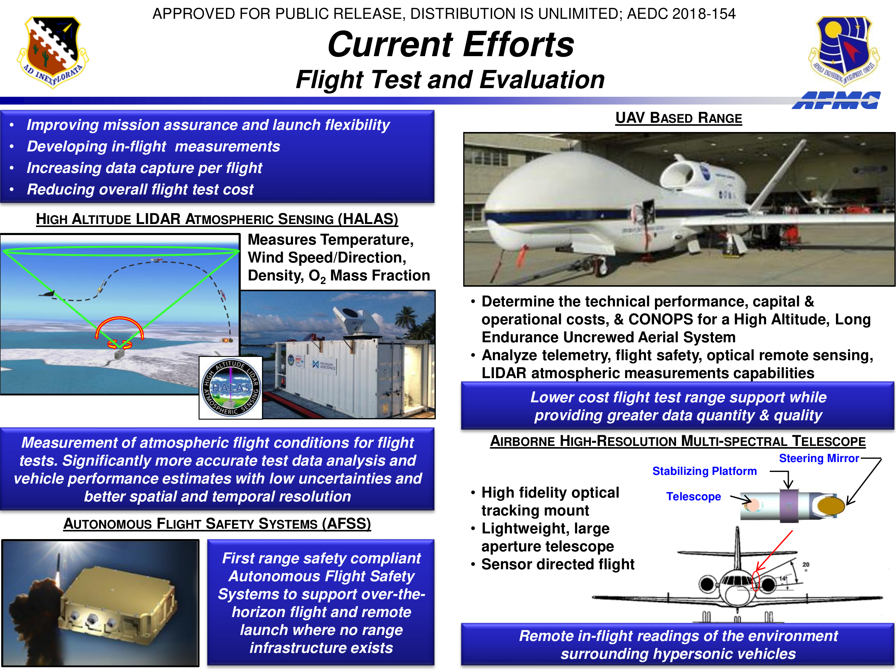 Image: Arnold Engineering Development Complex
The airborne version includes a note about “sensor directed flight”, a possible indication of an autonomous capability for an airborne atmospheric measurement system. Interestingly enough, previously mentioned observations of N515JA squawk codes and other aviation enthusiast theories hint at N515JA being capable of autonomous flight among its other noted modifications.
Additionally, a diagram of the airborne platform appears to show a twin-jet aircraft, with what appears to be an optical telescope on the left side of an aircraft, mounted at a roughly 14-20 deg elevation from horizontal. This is notable due to its apparent similarity with the observed modifications found on N515JA.
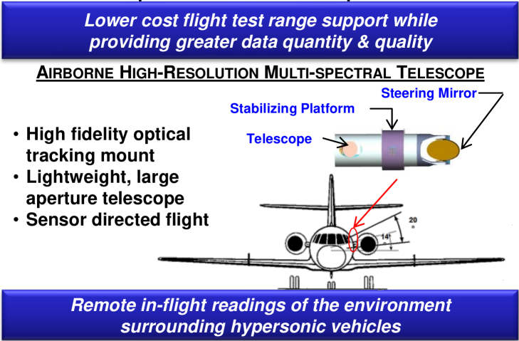 Image: Arnold Engineering Development Complex
Image: MT Aviation Photo & Film -MTrain999, via YouTube
Image: Arnold Engineering Development Complex
Image: MT Aviation Photo & Film -MTrain999, via YouTube
Finally, it was reported in September 2017 that the Naval Air Warfare Center Weapons (NAWC) Division at Naval Base Ventura County (NBVC) Point Mugu, California was slated to install a ground-based HALAS system to complement an existing atmospheric sensing platform, the Integrated Atmospheric Characterization System (ICAS).
Later this year, IACS will be partnered with the High Altitude Atmospheric Sensing (HALAS) system. HALAS, developed by Michigan Aerospace Corporation, is a long-range wind, density, and temperature measurement instrument capable of providing a critical real-time meteorological assessment of the troposphere and stratosphere. It is composed of an ultraviolet-based direct detection LIDAR system for wind velocity and direction, density and temperature measurements, combined with a Raman channel to measure nitrogen and oxygen concentration.
NAVAIR, September 7th 2017
Point Mugu
The Point Mugu Sea Range is an open-air test range that consists of a number of controlled airspace regions that includes five Control Area Extensions, one of which is closed for missile launches from Vandenberg AFB as well as hypersonic testing from both Vandenberg AFB and Point Mugu Sea Range.
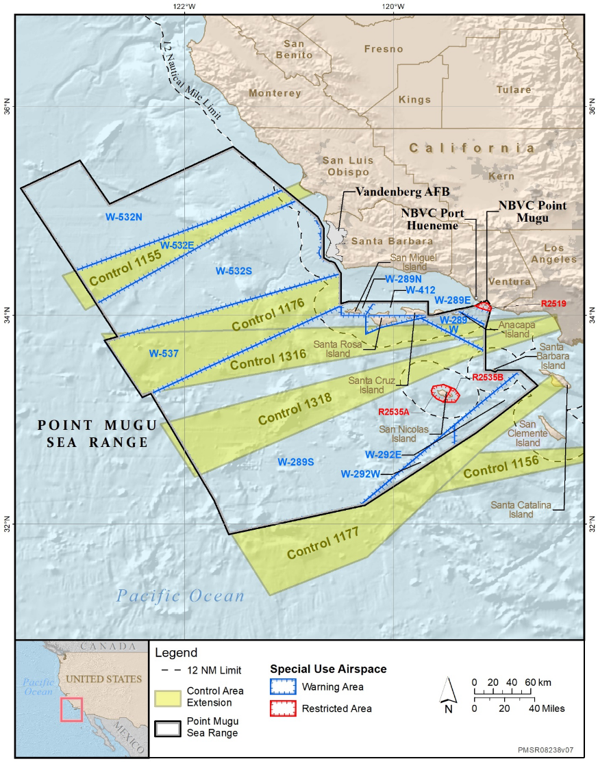 Image: Point Mugu Sea Range Environmental Impact Statement, April 2020
Notably, the Point Mugu Sea Range is considered part of the U.S. hypersonic testing infrastructure.
A Flight to Point Mugu
Throughout November and December 2020, N515JA flew a number of flights between KFCM (Minneapolis, Minnesota), KYIP (Detroit, Michigan) and KPHF (Newport News, Virginia).
Then, on December 2nd 2020, N515JA flew from KFCM airport outside Minneapolis to KOXR airport in Oxnard County, California.
KOXR airport is located roughly 7 miles northwest of Point Mugu.
Since arriving at KOXR, N515JA has to date (Dec 7th) flown three flights in and around the Point Mugu Sea Range.
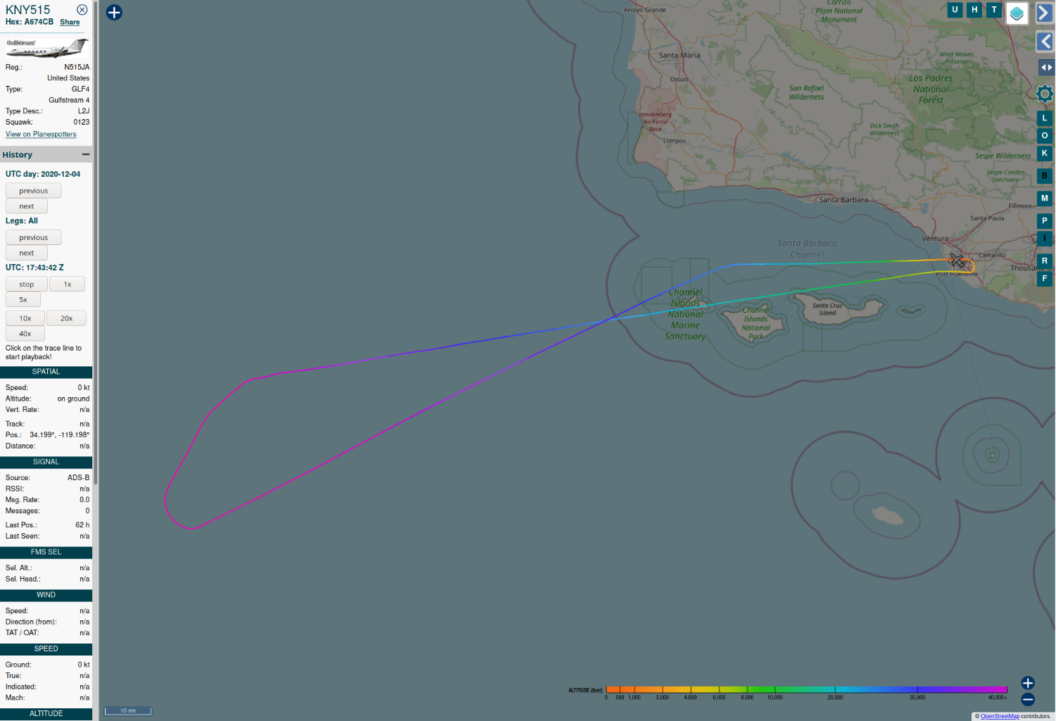 Image: ADSB Exchange
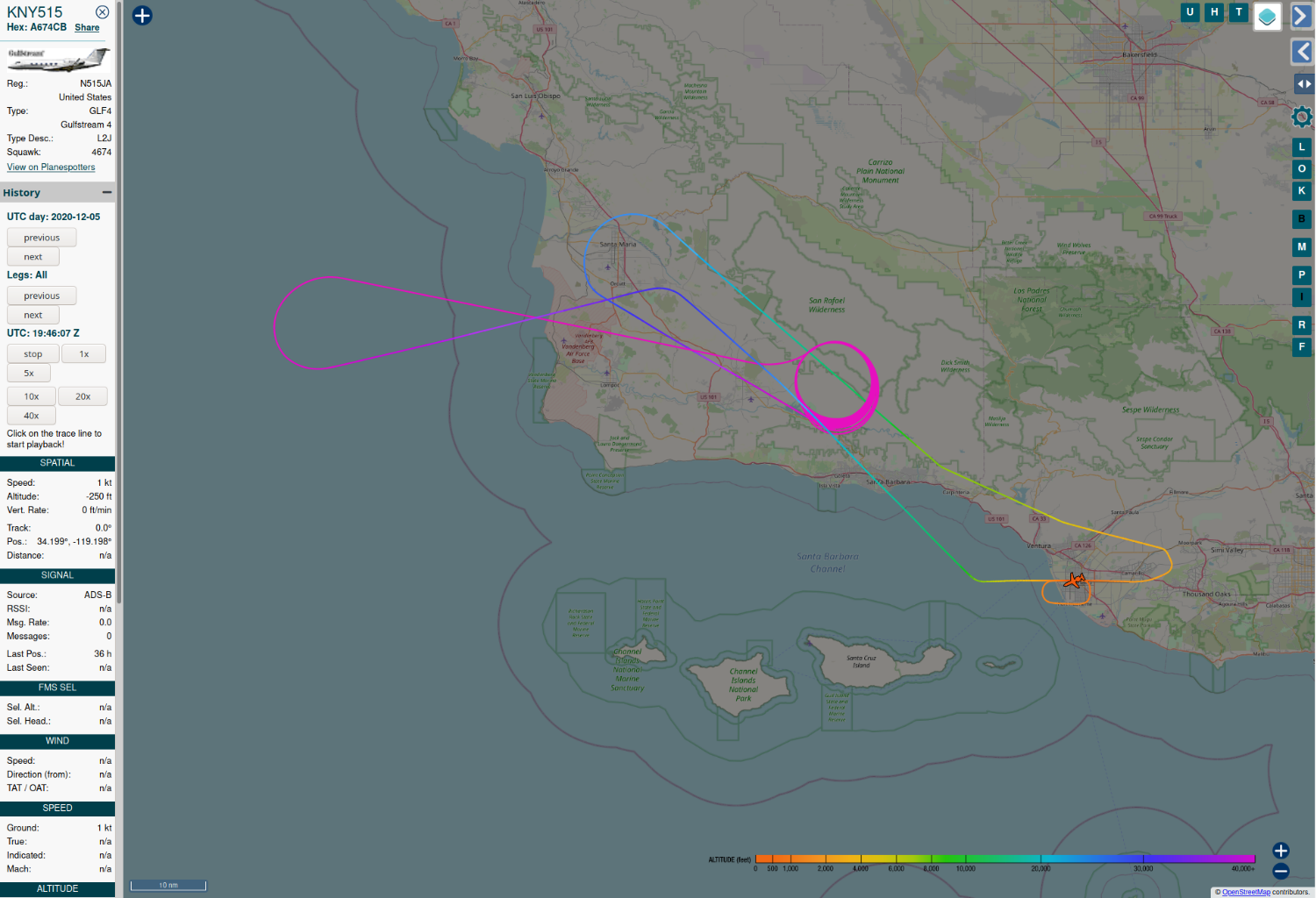 Image: ADSB Exchange
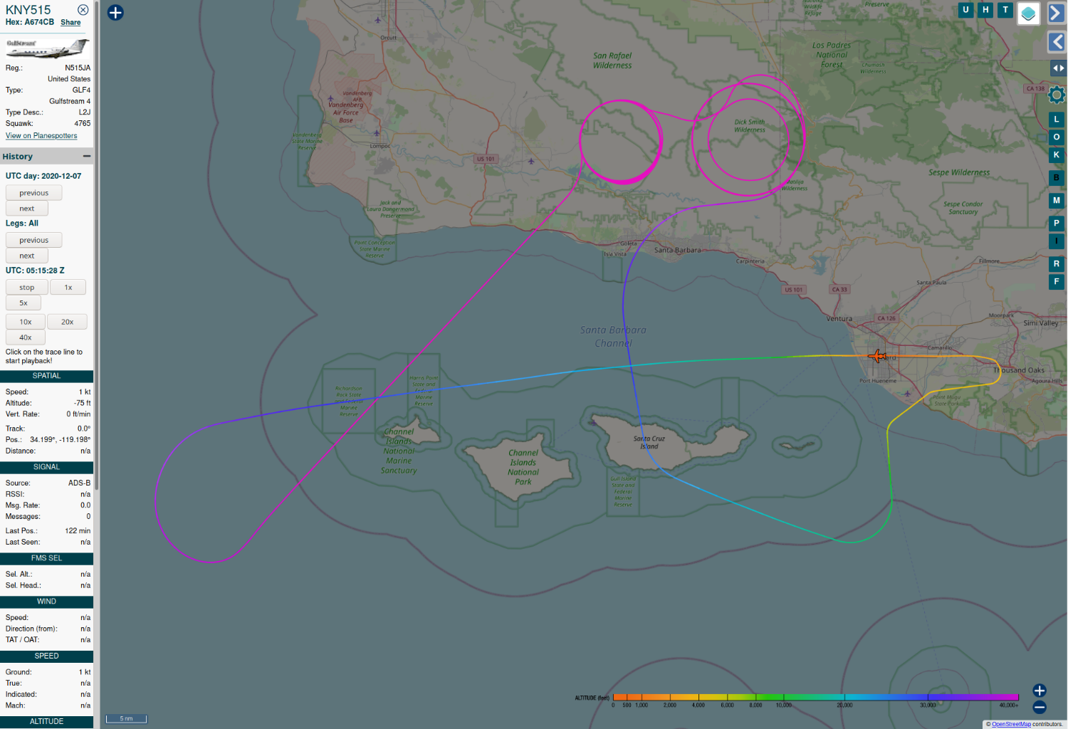 Image: ADSB Exchange
Conclusion
Based on the observations at hand (as summarized in Part 1 and Part 2), it would appear that N515JA is an airborne test platform for the High-Altitude LIDAR Atmospheric Sensing (HALAS) system.
In this capacity, it appears to be in development for eventual use as a measurement system during hypersonic missile flight testing by the US military.
As of December 2020, N515JA is potentially undergoing validation testing at the open-air test range at NBVC Point Mugu, likely in conjunction with a ground-based version of the HALAS system that was installed there in 2017.
These conclusions are a best guess effort based on the evidence at hand. This post will be updated with any new information if it becomes available.
- Posted on:
- December 6, 2020
- Length:
- 16 minute read, 3296 words
- See Also: