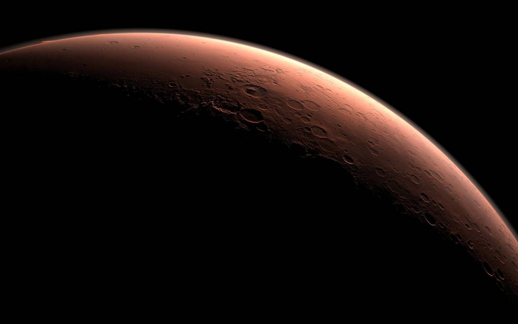
Liquid Water on Mars
By Jon Engelsman
July 27, 2018
Radar sounding measurements from the Mars Express Orbiter and the science behind liquid water on Mars.
 NASA
NASA
In a paper first released in Science on July 25th, 2018, a team of scientists from the European Space Agency (ESA) working on the Mars Express Orbiter announced the potential discovery of a large, underground liquid water aquifer under a Martian polar cap.
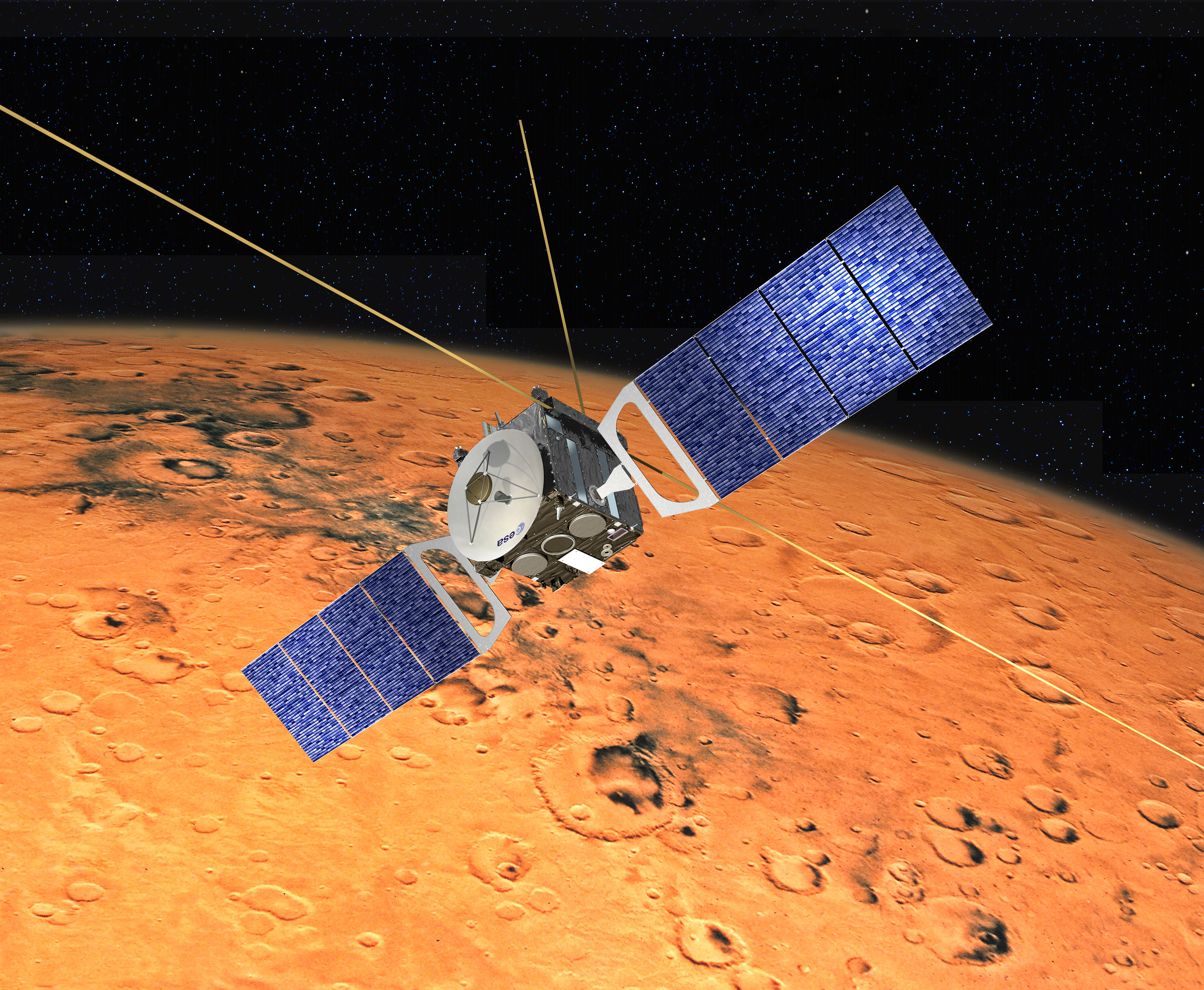
Mars Express Orbiter
 ESA
ESA
The Mars Express Orbiter is one of six currently active spacecraft orbiting Mars, launched from Earth in mid-2003 and inserted into Martian orbit later that year. Mars Express is comprised of seven scientific instruments that are being used to study the Martian surface and atmosphere.
 ESA
ESA
One of these instruments, the Mars Advanced Radar for Subsurface and Ionosphere Sounding, or MARSIS, detected an anomalous radar signature under the Martian surface near the Martian polar caps. During a measurement campaign between 2012 and 2015, MARSIS took a sequence of twenty-nine radar sounding measurements that detected a radar signature that is plausibly consistent with a large body of liquid water.
List of Articles
By now you’ve likely seen this news in one of many different science articles, so I won’t go into the whole story here. But I encourage you to read through a couple of the articles covering this story linked below.
1. “Scientists detect giant underground aquifer on Mars, raising hope of life on the planet”, The Verge, Loren Grush ( @lorengrush)
2. “Liquid water spied deep below polar ice cap on Mars”, Science, Daniel Clery ( @danclery)
3. “Scientists discover evidence of the first large body of liquid water on Mars”, Wired, Robbie Gonzalez ( @rtg0nzalez)
4. “Mars (probably) has a lake of liquid water”, Science News, Lisa Grossman ( @astrolisa)
5. “Liquid Water on Mars! Really for Real This Time (Probably)”, Planetary Society, Emily Lakdawalla ( @elakdawalla)
Also, since it’s always a good idea to read the source documentation, check out the actual paper published in Science below!
6. “Radar evidence of subglacial liquid water on Mars”, Science, Roberto Orosei et al
And last, check out the paper below if you want more technical detail on the MARSIS instrument itself.
7. “The Mars express MARSIS sounder instrument”, Planetary and Space Science, R. Jordan et al
Questions and Answers
Ok, let’s ask some questions about this work and pull out some answers from these papers and articles.
So, What Exactly Did They Find?
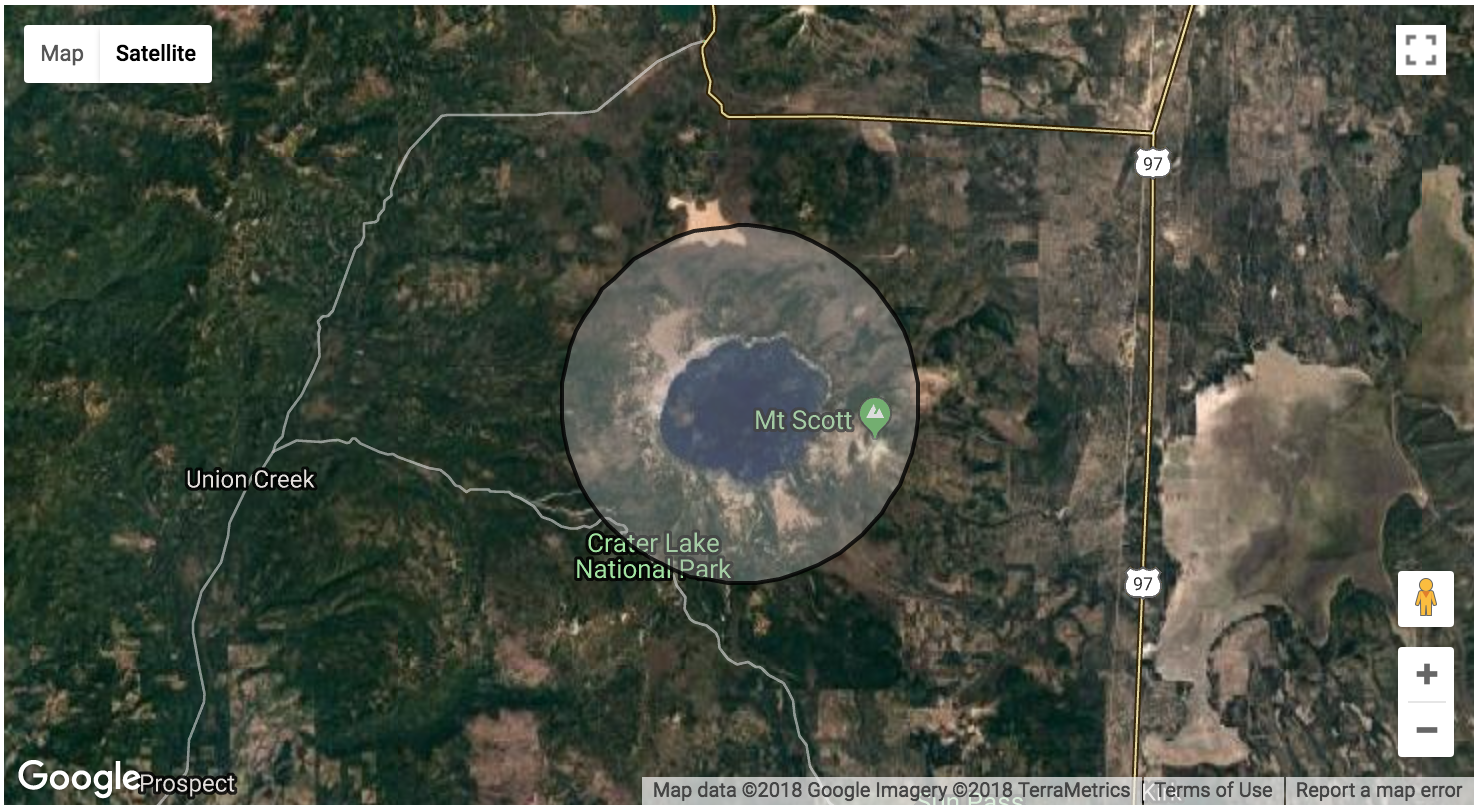
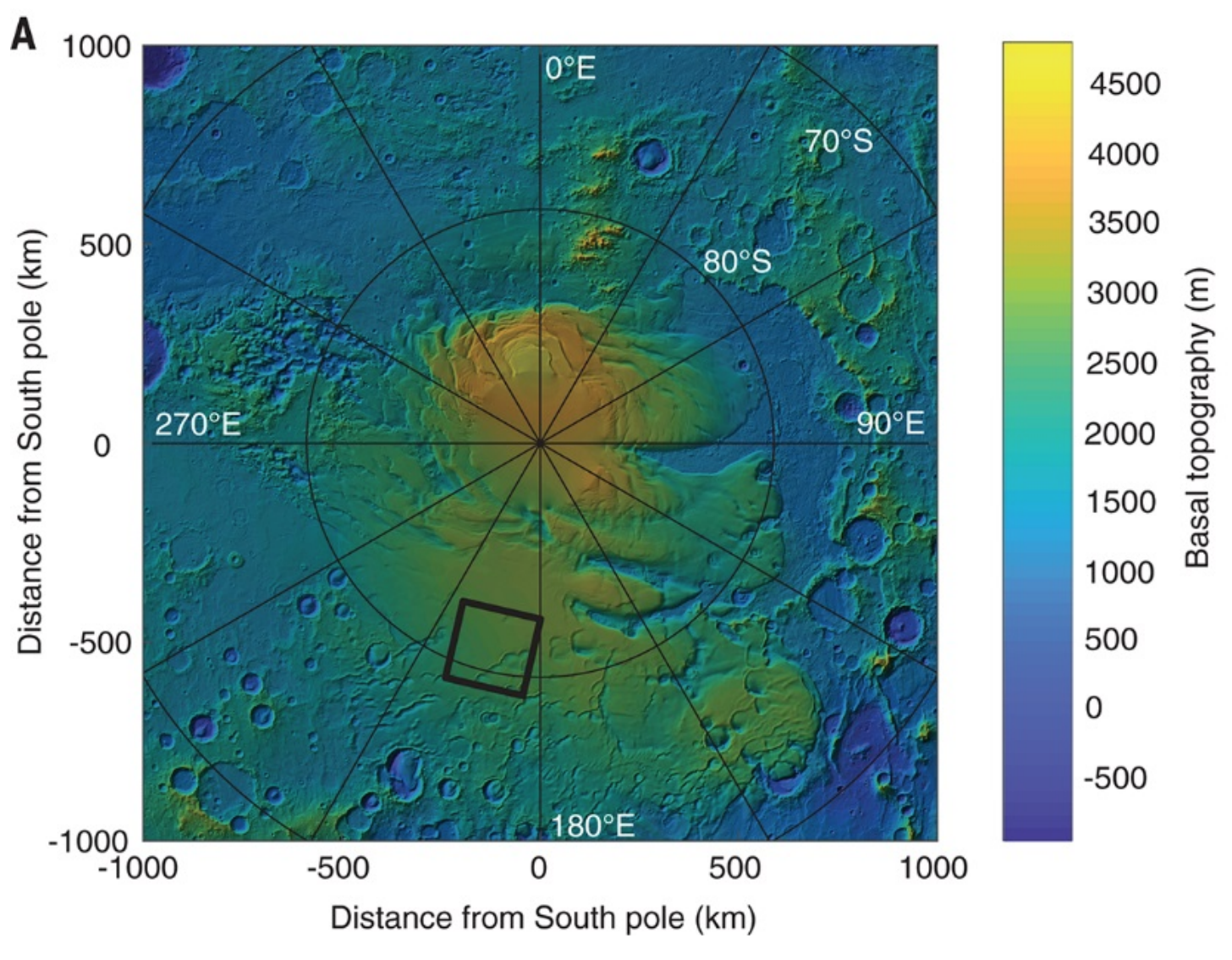
In short, European scientists discovered what appears to be an anomalous radar signature in the Southern polar cap region of Mars. Based on the evidence available, this radar anomaly appears to be a large, underground salty liquid water aquifer. About 1.5 kilometers under the Martian surface and about 20 kilometers wide (twice as large as Crater Lake in Oregon!), it’s the best and largest indication of liquid water that has been found on Mars to date.
-
“Radar profiles collected between May 2012 and December 2015 contain evidence of liquid water trapped below the ice of the South Polar Layered Deposits (SPLD)”, estimated to be a “20-kilometer-wide zone centered at 193°E, 81°S”. Ref #6
-
“Between 29 May 2012 and 27 December 2015, MARSIS surveyed a 200-km-wide area of Planum Australe, centered at 193°E, 81°S (Fig. 1), which roughly corresponds to a previous study area (8). This area does not exhibit any peculiar characteristics, either in topographic data from the Mars Orbiter Laser Altimeter (MOLA) (Fig. 1A) (11, 12) or in the available orbital imagery (Fig. 1B) (13).” Ref #6
-
"…bright reflections are localized around 193°E, 81°S in all intersecting orbits, outlining a well-defined, 20-km-wide subsurface anomaly." Ref #6
-
“Though the newly discovered lake’s depth is unclear, its volume still dwarfs any previous signs of liquid water on Mars, Orosei says. The lake has to be at least 10 centimeters deep for MARSIS to have noticed it. That means it could contain at least 10 billion liters of liquid water.” Ref #4
 Science
How Did They Take These Radar Measurements?
-
“The Mars advanced radar for subsurface and ionospheric sounding (MARSIS) on Mars Express is the first high-frequency sounding radar operating from orbital altitudes since the Apollo 17 Lunar Sounder flown in 1972. The radar operates from a highly elliptical orbit but acquires data only from altitudes lower than 1200 km. The periapsis altitude is 250 km. This radar has been successfully operating since August 2005. The radar is a dual channel low-frequency sounder, operates between 1.3 and 5.5 MHz (MegaHertz)with wavelengths between 230 and 55 m in free space for subsurface sounding and between 0.1 and 5.5 MHz (wavelengths between 3000 and 55 m) for ionospheric sounding. The subsurface sounder can operate at one or two-frequency bands out of four available bands at either like or cross polarization. The subsurface sounding radar transmits radio frequency (RF) pulses of 250 ms duration through a 40 m dipole antenna.” Ref #7
-
“The MARSIS antenna subsystem consists of a 40 m long dipole and a 7 m long monopole. The antenna structure is essentially a bridge of two parallel wires running the length of a support tube, which is made of fiberglass and Kevlar layers impregnated with resin. The antenna elements are made of foldable composite tubes that utilize a new technology developed by the Northrup Grumman called foldable flattenable tube (FFT).” Ref #7
-
“A total of 29 radar profiles were acquired using the onboard unprocessed data mode (5) by transmitting closely spaced radio pulses centered at either 3 and 4 MHz or 4 and 5 MHz (table S1).” Ref #6
-
“An interface between ice and water, or alternatively between ice and water-saturated sediments, produces bright radar reflections.” Ref #6
Did They Have Any Issues With The Measurements?
Oh yeah, plenty! To name a few, the MARSIS instrument has relatively low spatial resolution making it difficult to find small features; the instrument wasn’t calibrated on Earth because of its large size, so they can only make relative, not absolute, measurements; the radar signals get attenuated by the Martian ionosphere; and it took the scientists a couple of years to realize the spacecraft was “hiding” data due to an averaging process that was intended to help minimize bandwidth of data transfers back to Earth.
-
“The MARSIS design, particularly the very large footprint (~3 to 5 km), does not provide high spatial resolution, strongly limiting its ability to discriminate the presence of subglacial water bodies from the shape of the basal topography (10). Therefore, an unambiguous detection of liquid water at the base of the polar deposit requires a quantitative estimation of the relative dielectric permittivity (hereafter, permittivity) of the basal material, which determines the radar echo strength.” Ref #6
-
“Sounding the subsurface of Mars presents significant challenges as a low-carrier frequency is required to observe returns from below the surface. The ionosphere of Mars limits the frequencies for sounding; it also dictates a time-dependent observational strategy as the ionosphere plasma frequency decreases at night and increases during the daylight hours. The ionosphere is also influenced greatly by solar activity. Incorporated into the MARSIS instrument is an ionospheric sounder to aid the subsurface sounding frequency selection process, measure and remove the dispersion effects of the ionosphere, and study the ionosphere itself.” Ref #7
-
“Observations were performed when the spacecraft was on the night side of Mars to minimize ionospheric dispersion of the signal.” Ref #6
-
“The permittivity, which provides constraints on the composition of the basal material, can in principle be retrieved from the power of the reflected signal at the base of the SPLD. Unfortunately, the radiated power of the MARSIS antenna is unknown because it could not be calibrated on the ground (owing to the instrument’s large dimensions), and thus the intensity of the reflected echoes can only be considered in terms of relative quantities.” Ref #6
-
“For the first several years of observations, limitations in the spacecraft’s onboard computer forced the team to average hundreds of radar pulses together before sending the data back to Earth. That strategy sometimes cancelled out the lake’s reflections, Orosei says — on some orbits, the bright spot was visible, on others, it wasn’t.” Ref #4
-
“In the early 2010s, the team switched to a new technique that let them store the data and send it back to Earth more slowly. Then in August 2015, months before the end of the observing campaign, the experiment’s principal investigator, Giovanni Picardi of the University of Rome Sapienza, died unexpectedly.” Ref #4
-
“Later the team realized that the spacecraft’s computer was averaging across pixels to reduce the size of large data streams—and in the process, smoothing away the bright anomalies. ‘We were not seeing the thing that was right under our noses,’ says Roberto Orosei, a principal investigator (PI) for MARSIS at the Italian National Institute for Astrophysics in Bologna.” Ref #2
Why Do They Think It’s Liquid Water?
Well, for one, the strength of the relative radar echoes they measured are similar to ones that they have been measured by other scientific studies on Earth, specifically of subsurface ice-water boundary regions in Antartica and Greenland. They also ran some computer models of what the radar signals would look like for cold, briney water (their best estimate of the conditions on Mars) and it seemed to match their measurement data.
And because of how cold it is on Mars, liquid water could only exist if its freezing point had been lowered, either due to pressure from the ice caps above it or by salts that could be present in the liquid water, both of which are theorized to be likely conditions on Mars.
-
“On Earth, values greater than 15 are seldom associated with dry materials (26). RES data collected in Antarctica (27) and Greenland (9) show that a permittivity larger than 15 is indicative of the presence of liquid water below polar deposits. On the basis of the evident analogy of the physical phenomena on Earth and Mars, we can infer that the high permittivity values retrieved for the bright area below the SPLD are due to (partially) water-saturated materials and/or layers of liquid water.” Ref #6
-
“We examined other possible explanations for the bright area below the SPLD (supplementary text). For example, a CO2 ice layer at the top or the bottom of the SPLD, or a very low temperature of the H2O ice throughout the SPLD, could enhance basal echo power compared with surface reflections. We reject these explanations (supplementary text), either because of the very specific and unlikely physical conditions required, or because they do not cause sufficiently strong basal reflections (figs. S5 and S6).” Ref #6
-
“Although the pressure and the temperature at the base of the SPLD would be compatible with the presence of liquid CO2, its relative dielectric permittivity is much lower (about 1.6) (28) than that of liquid water (about 80), so it does not produce bright reflections…” Ref #6
-
“After all, it isn’t easy to explain the presence of water at Mars’s south pole. In Earth’s polar regions, the pressure of the overlying ice lowers its melting point, and geothermal heat warms it from below to create the subglacial lakes. But there’s little heat flowing from the geologically dead interior of Mars, and under the planet’s weak gravity, the weight of 1.5 kilometers of ice does not lower the melting point by much. Orosei suspects that salts, especially the perchlorates that have been found in the planet’s soils, could be lowering the ice’s melting point. ‘They are the prime suspects,’ he says.” Ref #2
-
“The substantial amounts of magnesium, calcium, and sodium perchlorate in the soil of the northern plains of Mars, discovered using the Phoenix lander’s Wet Chemistry Lab (29), support the presence of liquid water at the base of the polar deposits. Perchlorates can form through different physical and/or chemical mechanisms (30, 31) and have been detected in different areas of Mars. It is therefore reasonable to assume that they are also present at the base of the SPLD. Because the temperature at the base of the polar deposits is estimated to be around 205 K (32), and because perchlorates strongly suppress the freezing point of water (to a minimum of 204 and 198 K for magnesium and calcium perchlorates, respectively) (29), we therefore find it plausible that a layer of perchlorate brine could be present at the base of the polar deposits. The brine could be mixed with basal soils to form a sludge or could lie on top of the basal material to form localized brine pools (32).” Ref #6
-
“The radar brightness alone isn’t enough to prove that liquid water is responsible. Another clue comes from the permittivity of the reflecting material: its ability to store energy in an electric field. Water has a higher permittivity than rock and ice. Calculating permittivity requires knowing the signal power reflected by the bright patch, something the researchers could only estimate. But they find the permittivity of the patch to be higher than anywhere else on Mars—and comparable to the subglacial lakes on Earth. Although the team cannot measure the thickness of the water layer, Orosei says it is much more than a thin film.” Ref #2
Hmm, That Sounds Pretty Convincing…But Are We Sure It’s Water?
Of course not! A radar sounding is an indirect measurement when it comes to identifying a molecular compound like water. Until we drill down into the aquifer to do spectroscopic measurements, we cant be sure that the radar anomaly is liquid water.
On top of that, another radar instrument orbiting Mars, the Shallow Radar (SHARAD) on the Mars Reconnaissance Orbiter (MRO), hasn’t seen a radar anomaly in that area.
- “In the same location, higher-frequency radar observations performed by the Shallow Radar instrument on the Mars Reconnaissance Orbiter (18), revealed barely any internal layering in the SPLD and did not detect any basal echo (fig. S1), in marked contrast with findings for the North Polar Layer Deposits and other regions of the SPLD (19).” Ref #6
So How Do We Learn More About This Radar Anomaly?
Well for one, this discovery by the MARSIS team gives the SHARAD team a specific area of interest to target future radar measurements. SHARAD has a higher resolution than MARSIS, about 0.3 to 3 kilometers, so in theory it should be able to see the anomaly in better resolution, but it also operates at a different radar frequency that might not be sensitive to liquid water. So it remains to be seen if the SHARAD team can find the same anomaly in their measurements. But if they do, it might help corroborate the MARSIS hypothesis.
- “The next step in low-frequency sounding of Mars is already underway with the deployment of the shallow radar (SHARAD) on the Mars reconnaissance orbiter (Seu et al., 2007), which operates at a higher frequency than MARSIS, providing finer vertical resolution at the expense of subsurface penetration depth.” Ref #7
Any Other Missions to Mars That Might Help Do More Science On This?
Well, it’s probably fair to say that the location of this radar anomaly has gone to the top of the list for future science mission destinations on the Red Planet.
One mission already on its way, the InSight lander, will be focusing on temperature measurements below the Martian surface, although not nearly as deep as the radar anomaly. But, those temperature measurements will help out in our understanding of the geothermal properties of the planet, which will inform our understanding of the feasibility of liquid water under the surface.
This discovery also opens the door for new mission ideas, ones that might even include drilling down the 1.5 kilometers to try and get a sample analysis. The technology to launch and deploy a drill to Mars that could go down that deep doesn’t exist quite yet, but theoretically it’s possible.
While drilling for a sample analysis would be the ideal way to verify this discovery, there’s still a lot we have to learn about this radar anomaly. New orbiter spacecraft with advanced ground-penetrating radars could be used to analyze the anomaly in much higher-resolution and with calibrated antennae to better characterize the radar signatures to known material compositions.
I can also envision a suite of orbiters that work on a tip-and-cue model, where fast-flying orbiters do low resolution scans across the whole planet looking for anomalies and then flag regions of interest for slower-flying orbiters with higher resolution scanners.
-
“Fortunately, we may get some more answers about this area soon. In May, NASA launched a new lander to Mars called InSight, which is designed to probe the interior of the Red Planet and figure out its internal temperature. NASA’s Green says InSight’s heat probe could tell us how much heat is escaping the planet, and whether or not liquid water is even sustainable underneath the South Pole. “That instrument might be able to help us understand that the heat is adequate to keep this water liquid and not frozen,” says Green.” Ref #1
-
“InSight isn’t quite enough to truly confirm the existence of the lake — if it is a lake. NASA would need to send a robot of some kind to drill into the ice or send a more powerful type of radar to Mars with more sensitivity than the MARSIS instrument. There are no current plans to send a tool like that on any future Martian spacecraft. But Green says this discovery may lead to conversations about what kind of tool might make sense to send. “There has quite a bit of discussion by NASA and other agencies for doing that,” he says. ‘This now will have some urgency associated with it.’” Ref #1
The Tapestry of Planetary Knowledge
These types of discoveries are so fascinating to read about, first in news reports and then reading through the actual papers and work the reports are based on. They tell us the story of humankind’s efforts to understand our cosmos, and particularly our neighboring planets. These kinds of discoveries build on themselves and the work of teams all around the world.
We send a spacecraft, we learn something new and we learn more questions to ask. We send more spacecraft to answer some of those questions, then we learn something new and find even more questions. Our library of knowledge about our neighboring planets gets bigger and bigger, and our technology gets better and better. It’s a lovely story to see unfold in our lifetimes, and it’s beautiful to watch the tapestry of planetary knowledge being woven.
- Posted on:
- July 27, 2018
- Length:
- 15 minute read, 3073 words
- See Also: